State Secondary Highway 11-A once ran from Union Gap to Connell, Washington, passing through the town of Hanford on the shores of the Columbia River. The main Columbia River crossing at this location was originally located at White Bluffs, just upriver from Hanford. When SSH 11-A was established in 1938, the crossing was moved to Hanford. During World War II Hanford, White Bluffs, and the surrounding area were condemned by the U.S. Government to produce plutonium for the top-secret Manhattan Project. SSH 11-A was closed to the public at the borders of what eventually became known as the Hanford Site. It would remain closed through the 1950's. The military used the Hanford and White Bluffs ferry crossings to reach installations on the east bank of the Columbia River.
In the early 1960's a new branch of SSH 11-A was built through the U.S. Atomic Energy Commission Hanford Reservation to the town of Othello via a ferry at Vernita. The Vernita ferry was replaced by a toll bridge in 1965. This bridge is a two lane version of the modern Vantage Bridge upriver. It was designed to span the pool of the never-built Ben Franklin Dam. This highway is now part of the modern SR 24.
The original eastern portion of SSH 11-A remained in the state highway system for several years. It kept its original designation until the 1964 renumbering. The section between Mesa and the Columbia River became SR 170; this road was decommissioned around 1970 (the number was transferred to the highway entering Warden from SR 17). The SR 17 to Connell section became part of SR 260.
Today the portion of the Hanford Site east of the Columbia River is under the jurisdiction of the U.S. Fish and Wildlife Service and is open to the public. The Hanford Site was declared a National Monument in 2000 by President Clinton. The old ferry landings on the east bank of the Columbia River can be accessed by vehicle.
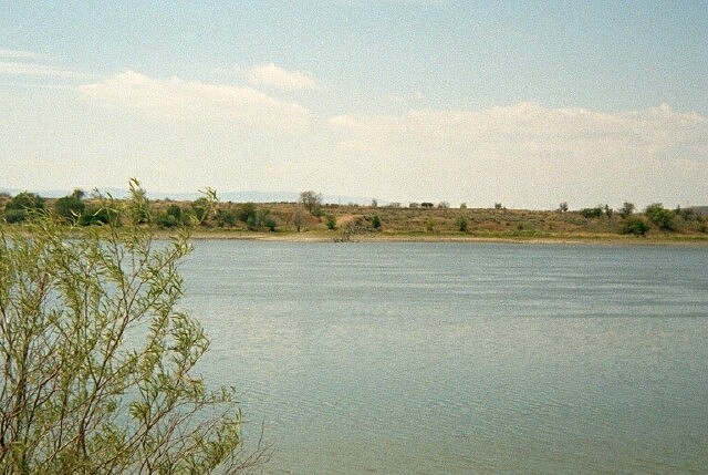
I believe that this is the site of the Hanford ferry crossing. Note the old road sloping down the bank on the far side of the river in the middle of the picture. Behind me is a segment of very old one lane blacktop road which curves upriver. This scene is located just downriver from the old Hanford townsite.
Picture taken May 2001.
(historical information source:Ruby, Robert H. and John A. Brown. Ferryboats on the Columbia River Including the Bridges and Dams. Seattle, Superior Publishing Company, 1974. Library of Congress card number 74-75658.)